South Route 2022
We came right down to the wire plotting our 2022 South Route. Of course, we knew there was one "anchor point" chiseled in stone: Our October 24th Capitol Reef camping reservation. We made that reservation back on April 24th. We once again snagged Site # 30 in the B Loop. That's the spot we consider to be The Best in the NPS Fruita Campground.
OK, we waffled for weeks about how to get from Idaho Falls to The Reef. Finally we decided to pass alongside Bear Lake and camp for a night or two. Bear Lake then became "anchor point" # 2. But the devil's in the details and, aside from the two anchor points, we really didn't know which routes we would be taking.
Plus, there's a Weather Wild Card in the works...and it looks like a potentially significant wild card. So, how would that affect the routing and camp selections?
In any event, as of the afternoon of October 18, we 'think" we have it figured out. We had planned to leave tomorrow afternoon and go camp below Palisades Dam which is less than 90 minutes from home. We've scratched that idea and will simply leave early Thursday to drive all the way to Bear Lake.
However, we threw a wrinkle into the Bear Lake Plan. Instead of camping at Rendezvous Beach on the far south shore, we're going to turn left (east) at St. Charles and loop around the East Side of the Lake. We'll camp in either the Idaho or Utah state park over there.
Chances now are pretty good that we will only spend one night at Bear Lake. We'll drive down to Evanston, Wyoming, and then head west through history-drenched Echo Canyon to history-sodden Echo, Utah. (Yes, that part of Utah is literally dripping with history.) Then we turn south into the Upper Weber River Watershed.
Depending on the weather forecast(s) we "might" camp at Rockport State Park near Wanship, a hamlet named in the 1850's for a friendly Ute Native Chief. Currently, Rockport Reservoir has a toxic algal bloom so we will debate camping there.
If we don't camp at Rockport, we're heading all the way south to Palisade State Park south of Manti on US 89. That's a long haul from Bear Lake so "we shall see," as they say. A lot of our planning has to remain fluid (pun intended) because of the forecast rains.
An Eagle Scout marked the Utah Center. Here's a fine 2008 story about his project:
 |
| The red push pin is the Utah Center. The red line is US 89. It's mighty fine. |
We've camped at Palisade a couple of times. It has a TINY little reservoir and a really BIG golf course. Go figure.
After leaving Palisade we're probably going 13 miles out of our way to cruise the east flanks of Fishlake Mountain. We'd be hoping to see some aspens in their full fall gold colors.
 |
After 5 nights at The Reef we're NOT going through Hite to Blanding as we've done in the past couple of years. Nope, we're heading West on UT Hwy 24 over to UT Hwy 62 and thence south to Otter Creek Reservoir. There's a short stub of UT Hwy 22 that ends at Antimony. Beyond that it's county roads until reaching UT Hwys 12 & 63 at Bryce Canyon City.
If the weather is good we will camp at Bryce for at least a night, maybe 2. Then it would be West on UT Hwy 12 through scenic Red Canyon to US 89 once again. Naturally, we'd turn south and cruise all the usual suspects from Hatch to Long Valley Jct., Glendale, Orderville and Mt. Carmel. We will definitely be spending some quality time in Orderville to pay homage to The Big Indian.
We first "discovered" The Big Indiana in October 2017 when we began studying US 89 from Mexico to Canada. We were totally perplexed about the "Let Our Big Indian talk to your kids." What the heck did that mean? Anyway, a few months ago, Renowned Author and Ace Sleuth Virgil Alexander decoded the meaning of the postcard. The developer of the Lodge wired a speak into the head of the statue. When a tourist came into the office, he or she was offered a chance to have the Big Indian speak to their kids. If the tourist gave the lodge owner some choice tidbits about the kids, the Big Indian would talk to them in a very personal way. It was a popular tourist attraction and, supposedly, traveling Navajos liked to stop and sing Native chants through the speaker. THANK YOU, Virgil.
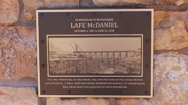
It's kind of a long haul from Bryce to Marble Canyon but that's our destination. We will be basking in the glow of the Vermilion Cliffs while we stage to delivery a Eulogy for the Late Lafe McDaniel who died in June 1928 during construction of the Navajo Bridge. Of course, there is always the totally obligatory pilgrimage to Lees Ferry to pay our respects to "that river." You know the one.
 |
| Photo courtesy Tom Martin |
When our various social appointments are complete at Marble Canyon, we're finally off on The Home Stretch up Tanner Wash and down Hamblin Wash into the western fringes of The Painted Desert through Little Colorado Country and across the East Kaibab Monocline.
Once we climb onto the volcanic skirts of The San Francisco Peaks we will finally get a glimpse at some of the damage from the Tunnel and Pipeline Fires this year.
Upon reaching Flagstaff the heavy traffic slog begins. We hear there might be some construction delays on I-17. Whatever. However, once we reach the lip of the Mogollon Rim, it's all downhill from there.
If everything goes according to "Plan," we will be home sometime during the first few days of November.


Comments
Post a Comment