Posts

Showing posts from August, 2023

Introducing South Route 2023

Image
Tanks a Lot!  We're already found two hidden small town gems* on South Route 2023.   Each year's South Route choices are always an adventure.  We always travel much slower and farther traveling South to Arizona than we do heading back North to Idaho.  Two of the primary reasons for this disparity are time and wind.  Let's face it.  Spring is always much windier than fall, sometimes extremely so.  Likewise, we typically have the "horse back to the barn" mentality and want to get to our Idahome as soon as possible.  That's why the North Route is so predictable.  It's pretty much always the same. Meanwhile the South Route allows for a lot more creativity.  Time is not a factor.  "We'll get there when we get there" is sort of an unofficial timeline for each year's South Route.  We tend to look at the South Route like a vacation.  More often than not, we will tend to spend ten days or more meandering South while perhaps 3-...

Wyoming 2023

Image
The first leg of our South Route 2023 is Idaho Falls to Green River, Wyoming.  There are two primary ways to get from here to there.  Oddly BOTH of those routes are precisely the same mileage as measured by Mapquest Dot Com.  Since we've traveled most of one route many time, we picked the route which takes us deeper into The Cowboy State.   We enter Wyoming a few miles East of Alpine, Wyoming.  We're no strangers to this route as we've taken it seemingly countless times.  US Highway 26 intersects US 89 at Alpine. We turn North at that intersection and head into Snake River Canyon.  Today's highway through the Canyon is danged close to interstate highway standards.  It's an EZPZ, high speed route that funnels both tourists and workers from Star Valley north to the mega views and mega money of Jackson, Wyoming.  Lots of people who can't afford to live in Jackson call Alpine home and then commute to the relatively high paying jobs in Jackso...

John Hoback

Image
Hoback Canyon's name dates back to 1811 when The Astorians passed through. We turn east at Hoback Junction. At one time, US 89 actually followed the Hoback River to get to Jackson.  That's back when engineers didn't have the heavy equipment and technical capabilities to tame the Snake River Canyon.  There's a real nice highway through Hoback Canyon. Interestingly, it received it's name as a result of the Wilson Price Hunt Expedition of 1811.  The members of that expedition were called "The Astorians" and we just finished a gripping, dramatic book detailing the group's perilous travels through the area.  John Hoback helped guide The Astorians and that's how Hoback got its name.  Supposedly, Hoback's grave is located in the vicinity.  If possible we will try to find it. We will be camped our first night at Hoback Campground.  Even though the Forest Service will have closed the campground on September 30, they don't lock it up like they do the...

Bondurant

Image
Jackson has a long reach around the region. This iconic 1930's image* is still part of Jackson lore. Bondurant is the next Road Trip highlight after leaving Hoback Canyon.  In fact, Bondurant is still smack dab in Hoback Country.  The whole area around Bondurant is known as Hoback Basin. I hate to admit I didn't expect much out of Bondurant.  In fact, I've always had a suspicion Bondurant was named for a race car driver.  I figured he had enough money to buy his own town.  HAHAHA!.  Bondurant has nothing to do with the racing guy.  It's a high, cold area with almost no growing season so it was a Johnny-come-lately in the days of Pie Near Settlement.  Finally some guy named B.F. Bondurant decided to throw down and set up shop there and, voila, Bondurant was born.  It's Post Office dates to the 1890's.  In typical Wyoming style, Bondurant has always been all about the symbiotic relationship between cowboys and cows. Even if you can't grow ...

Save The Hoback

Image
 The deeper we dig the more and MORE interesting stuff we uncover.  We had no idea that the Upper Hoback River was such a hotly contested area or that the natural gas drilling was staved off.  It's quite a story.  We think it's possible drive out and camp in some of that purple area--maybe on Cliff Creek Road.  Hopefully, we will get to see some of the "rescued lands". For a decent short video of the area and the campaign see: https://youtu.be/jq0RwHyFsUw?feature=shared As the southern anchor of the Greater Yellowstone Ecosystem—the largest intact temperate natural system in the Northern Hemisphere—the Hoback Basin is home to magnificent mountains, vibrant forests, and the headwaters of the Wild and Scenic Hoback River. Generations of Americans have come here to fish, hunt, paddle, hike, or to simply enjoy Wyoming’s backcountry. But the future of this unspoiled landscape was at risk, for beneath the Hoback lies a highly valued resource—natural gas. Specifically,...

Warren Bridge

Image
Warren Bridge seen here beside the new alignment of US 191 is the most heavily used crossing in the far upper Green River.  Although there are a few minor bridges upriver, none carry anywhere near the amount of traffic that the Warren Bridge Crossing does.  For current webcam photo use link below: https://www.wyoroad.info/highway/webcameras/US191WarrenBridge/US191WarrenBridge.html Warren Bride is also notable because is is a major USGS stream gaging site for the Upper Green River.  In addition to the majestic headwater flows of The Green River, it picks up numerous side streams between the headwaters and highway US 191.  Note also there is a BLM campground immediately downriver from the bridge and highway. As of late August, The Green River at Warren Bridge was running a wimpy 380-something cfs.  Obviously, the river at this location can really kick up its heels during spring runoff! Warren Bridge is actually near a modern battle field.  Say what?  Wel...

Daniel

Image
Video tour:  https://www.facebook.com/watch/?v=609539592980444 https://wgfd.wyo.gov/About-Us/Offices-and-Facilities/Daniel-Fish-Hatchery    https://cowboystatedaily.com/2023/07/08/landmark-green-river-bar-in-daniel-aka-the-grb-is-a-glorious-wyoming-dive-bar/ If you would go to a rendezvous and ask several people how they got involved, you would receive many answers. Some would mention their interest in black powder rifles and pistols. Others would speak of their enjoyment of historical reenactments. Some would say they were drawn to it by curiosity or the challenge. Others, like myself, were drawn to the image of the mountain man and his independence, freedom and adventurous life.     Most of those interests are addressed at a rendezvous. For the black powder enthusiast, there are usually shooting competitions. There might be a woods walk for those who want to test their wilderness skills. And there are "best camp" and "best dressed" awards for those w...

Mountain Men

Image
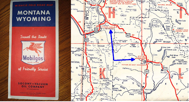
  What does a 1950's road map have to do with Mountain Men? A lot.  Modern maps miss most memorable markers. We turn to old road maps to find stuff not shown on newer maps. We happen to physically own this particular Mobilgas map*. That's how we discovered the Samuel Parker Monument shown above.  Practically every map of every age and stripe shows the Old Fort Bonneville marker but this is the only map we've found that shows the Samuel Parker Monument.  Why is that relevant? Well, if you begin to study Samuel Parker, you quickly get sucked into the endless galaxy and universe of early trappers who were also called Mountain Men. You see, this area of Wyoming literally drips with Mountain Man history.  The Upper Green River was sort of a vortex that attracted thousands of Mountain Men for the epic annual rendezvous. Samuel Parker had the audacity to attempt to preach The Word of God to the barbarian Mountain Men and so that's why Parker has his own monument. ...

Alfred Jacob Miller

Image
z https://alfredjacobmiller.com/  

Big Piney

Image
 Big Piney https://www.grvm.com/

La Barge

Image
  La Barge touts itself as a small community nestled in the peaceful Green River Valley and claims to be "Home of The Frontier Trapper".  There's not much going on in La Barge and that's what makes The Moon Dance Diner Story stand out.  The Moon Dance Story begins as a classic "hope springs eternal" small town saga.  The once vibrant Moon Dance dreams fell on hard times and the story faded to a sad ending. It all began sometime in 2007 when lifelong La Barge residents Vince and Cheryl Pierce somehow became smitten with the idea to buy an iconic New York City diner--The Moon Dance.  The couple paid $7,500 to buy the building but then spent thousands more to move it to La Barge.   Then the real spending began and the Pierces ultimately invested around $300,000 in the little diner.  It opened with great local fanfare in late January 2009.  Unfortunately, the age-old business mantra "location, location, location" was not kind to the Moon Dance an...

Fontenelle

 Fontenelle

Seedskadee

 Seedskadee

Lombard Ferry

   https://www.wyohistory.org/encyclopedia/lombard-ferry-green-river

Big Island Bridge

Image
  https://www.sweetwaternow.com/museum-shares-history-of-3-bridges-across-the-green-river/

Tie Drives

Image
Green River tie drivers after another successful annual run.  Believe it or not, The Green River was once totally choked each spring with tens of thousands of "ties".  Yep, railroad ties! Ties drives were a huge Big Deal not only on The Green but also The Wind River and all of the Utah streams than drained out of forested land.  However, The Green's tie drive were arguable The Biggest and The Best of them all. The quoted text below is from the last page of a "Self-Guided Tour of Historic Green River". (NOTE: Note publication date, author's credit or any other pertinent info is given in the publication. We found the publication on our most recent trip through Green River 20 years ago.) "The remains of the tie booms in the middle of the river and the remains of the tie dock can be seen in the north bank of the river downstream from the Wyoming Highway bridge in Green River. The drives were an annual affair each spring from 1868 until 1941. The ties were ...

Thomas Moran

Image
  In June 1871, Thomas Moran, a gifted young artist working in Philadelphia, boarded a train that would take him to the far reaches of the western frontier and change the course of his career. Just a few months earlier he had been asked to illustrate a magazine article describing a wondrous region in Wyoming called Yellowstone—rumored to contain steam-spewing geysers, boiling hot springs, and bubbling mud pots. Eager to be the first artist to record these astonishing natural wonders, Moran quickly made plans to travel west. Yellowstone was Moran's ultimate destination in the summer of 1871, but before he reached the land of geysers and hot springs, he stepped off the train in Green River, Wyoming, and discovered a landscape unlike any he had ever seen. Rising above the dusty railroad town were towering cliffs, reduced by nature to their geologic essence. Captivated by the bands of color that centuries of wind and water had revealed, Moran completed a small field study he later insc...

Green River, Wyoming

Image
 Green River, Wyoming There have been numerous "Green River" communities sprinkled along the Green River, a stream which has had its share of different names, too.  Chances are pretty good that the river was called the "Green" about 200 years ago.  Every now and then someone called it the "Spanish River".  The local Natives called it the Seedskadee which mean "Prairie Hen River". When the Union Pacific railroad surveyors began pondering how to cross Wyoming, a route through what is now Green River was very much up in the air.  Some want to go up through the South Pass route.  The more southern route had to traverse the dreaded Red Desert.  Eventually, the rail line skirted the southern edge of the Red Desert and ID'd a crossing to its liking below a prominent landmark named The Citadel. Naturally, a lot of people learned about the route and the crossing and a town sprung up even before the railroad bridge was built.  The town usurped the name...